资料同化研究与应用中心团队杨胜朋副教授和邹晓蕾教授在国际主流期刊Journal of Climate发表了题为“Comparison of TC temperature and water vapor climatologies between Atlantic and Pacific Oceans from GPS RO observations ”的论文。
云一直是影响卫星观测的重要天气因素,即使是有很强穿透性的微波探测,依然有很多云类(特别是深厚的云)通过对辐射的散射和吸收对微波探测资料造成严重的影响。然而,云雨区往往是对预报有着重要影响的敏感区域, 这些区域的卫星观测包含有很多很重要的天气信息,尤其像台风这类高影响天气。
GPS掩星是一种临边探测技术,和一般的卫星观测探测原理有本质的不同。GPS掩星资料具有高精度、高垂直分辨率、受云雨影响较小、无需定标、没有频率漂移等特点,它不仅提供了温度场,同时,还提供了水气场。将GPS掩星资料用于台风结构研究,对于了解台风结构特征具有重要的科学意义。
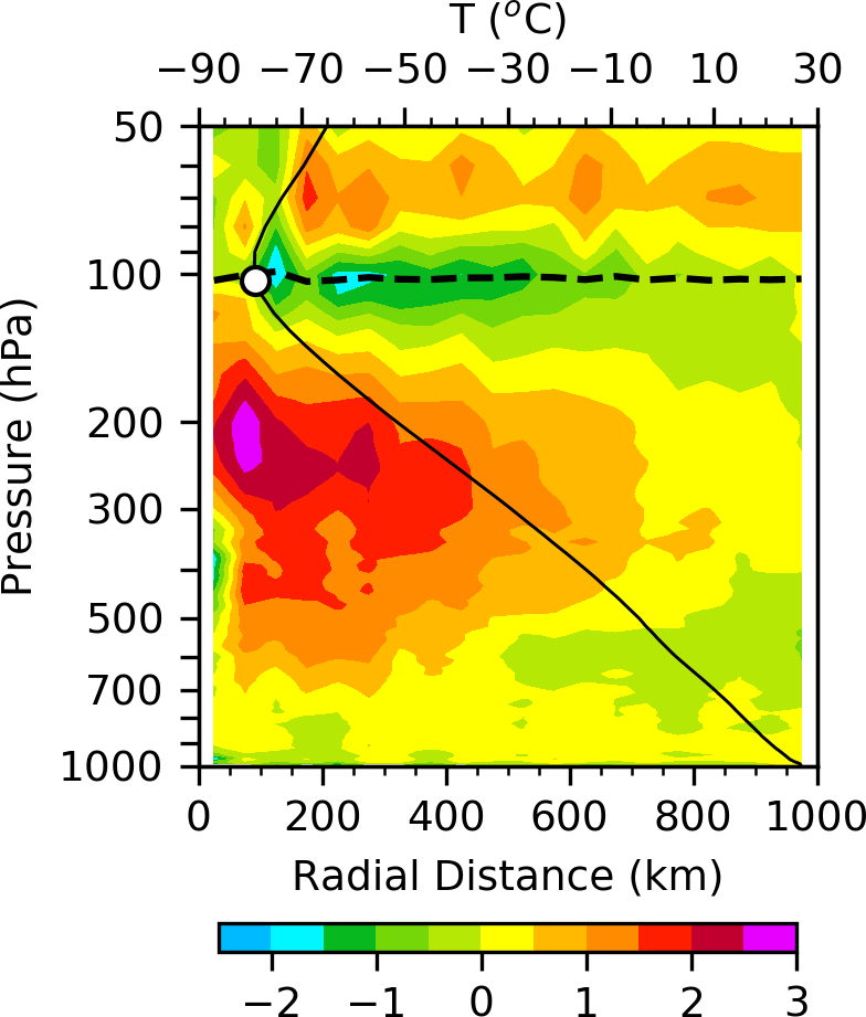
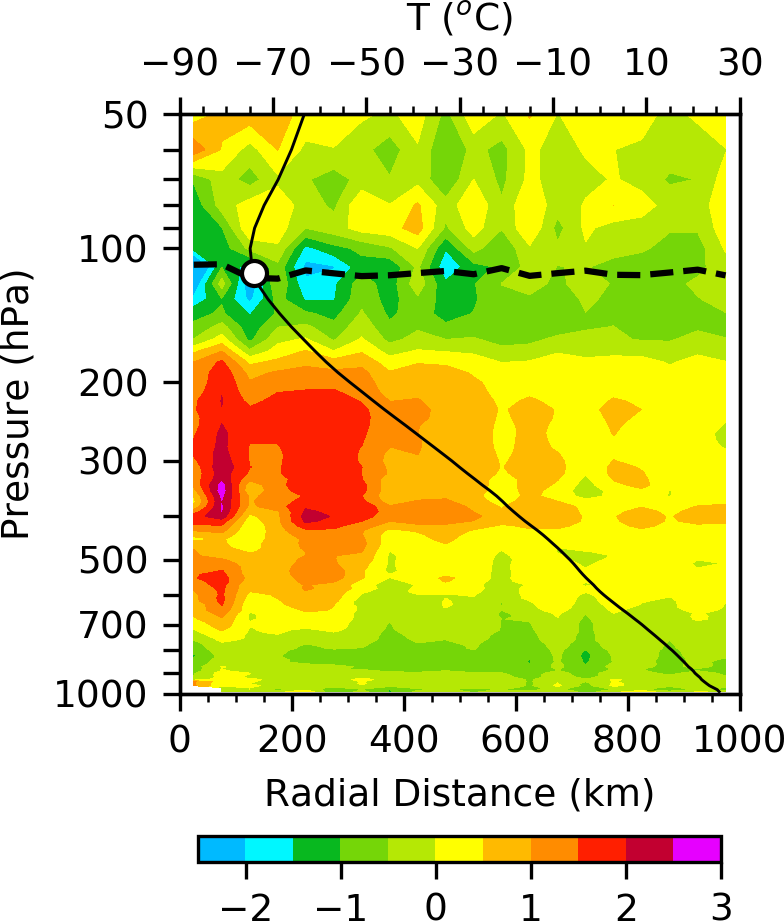
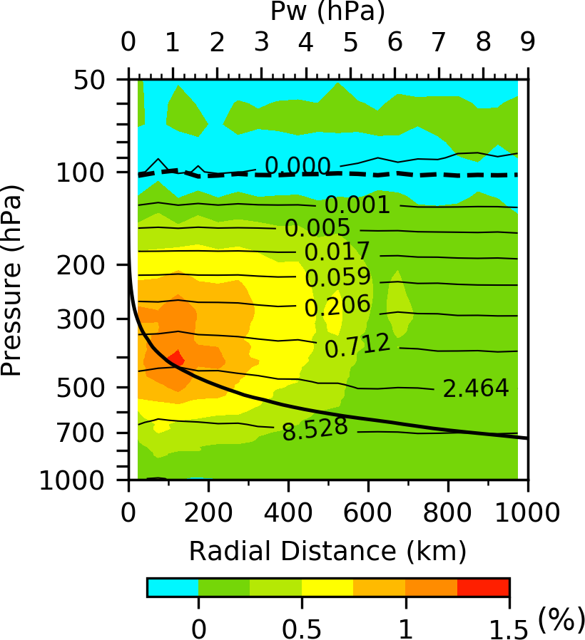
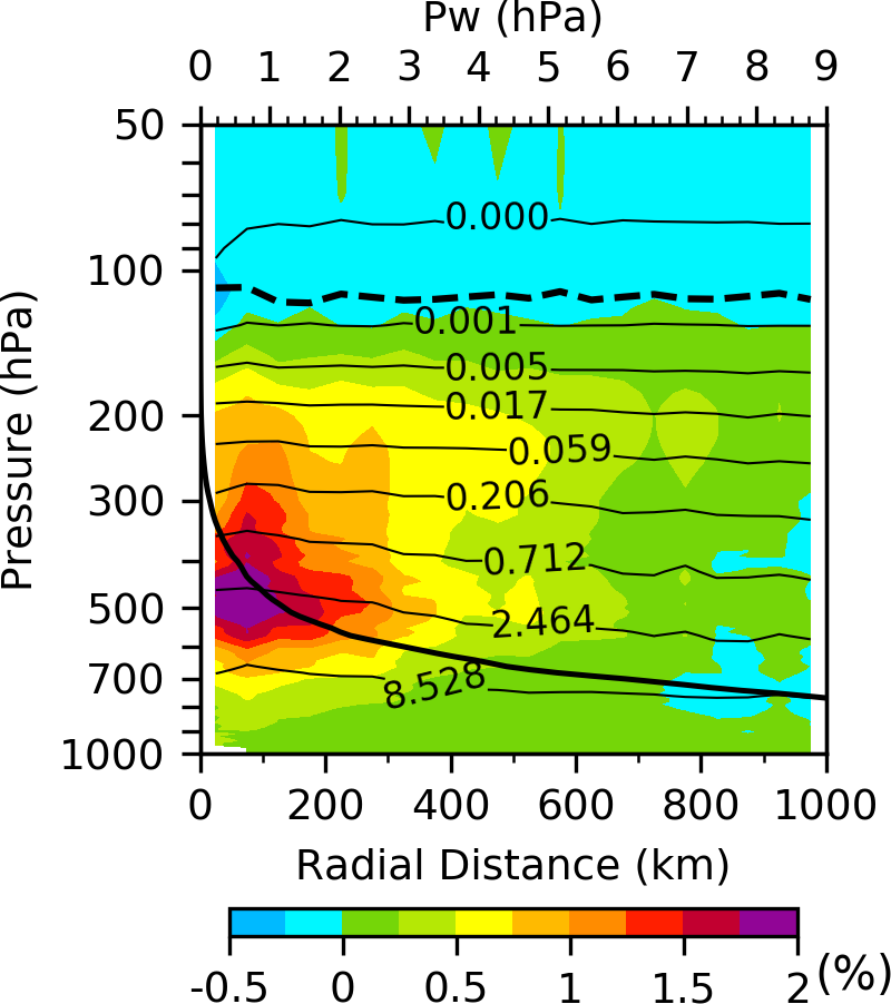
利用2007-2015年COSMIC, MetOp-A和MetOp-B掩星资料,分析了西太平洋和大西洋上热带低压(TD),热带风暴(TS),台风(TY)/飓风(HU)内核温度和水汽三维结构特征。从10年的统计结果来看,西太平洋上不同强度的热带气旋“暖心”的高度比大西洋上的高,“暖心”的强度也比大西洋上的更强。西太平洋上热带气旋的“湿心”比大西洋上更深厚,但是,“湿心”的强度比大西洋上的要弱。
文章链接:
https://journals.ametsoc.org/doi/abs/10.1175/JCLI-D-18-0074.1
Yang, S., X. Zou, and P. Ray, 2018: Comparison of TC Temperature and Water Vapor Climatologies between Atlantic and Pacific Oceans from GPS RO Observations. J. Climate. doi:10.1175/JCLI-D-18-0074.1


FIG. 8. Composite temperature cross-sections (colored shading, unit: oC) and tropopause height (black dashed lines) for typhoon/hurricane (TY/HU) categories derived from collocated RO data over the western Pacific (left panels) and Atlantic (right panels) Oceans. Also shown are mean RO environmental profiles (black solid lines) and the tropopause (white dots) calculated from all collocated ROs with radial distances from 1000–1300 km at the same latitudes as the collocated TC centers.


FIG. 9. Same as Fig. 8 but for the fractional water vapor pressure anomaly (calculated as [(e-eenv)/eenv], colored shading), water vapor pressure (contour lines, unit: hPa), and the vertical profile of the environmental water vapor (Pw, thick black solid lines). The black dashed lines show the tropopause heights.