厄尔尼诺(El Nino)是发生在热带太平洋最显著的气候异常信号,它与我国夏季降水异常之间存在着复杂的联系。研究厄尔尼诺在发展阶段对东亚夏季降水的影响及物理机理,对提高我国夏季降水预报能力、减少预测不确定性有重要意义。
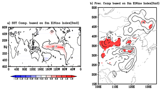
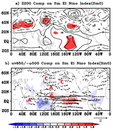
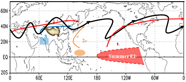
大气科学学院温娜副教授团队的研究结果表明:在发展阶段,El Nino对我国夏季降水异常的影响直接通过其自身的热带太平洋海温异常来实现的;降水异常呈三级型分布,华南及华北降水异常增多,而华北降水异常偏少。厄尔尼诺对环流影响主要通过三条途径来实现:(1)赤道中东太平洋对流扰动通过东北太平洋副热带南支急流激发的纬向波列在急流里的传播;(2)热带西太平洋对流活动激发了季风槽扰动,进而导致了沿东亚沿岸北向传播的罗斯贝波列;(3)厄尔尼诺间接引起的印度北部对流活动的减少对邻近急流的扰动激发了下游波动的传播。

Figure1 a) Composite global SST anomalies based on summer El Niño index. The red (blue) shading with white solid (dashed) line is for the positive (negative) value with contour interval (CI) of 0.3℃. b) Corresponding composite summer precipitation anomalies (relative variation, in percentage) over East Asia. The solid (dashed) line denotes the positive (negative) values with CI = 5%. The thick black contour in Fig.a and red shaded in Fig.b indicates the 90% confidence level.

Figure2 Composite atmospheric anomalies in the tropical-northern hemisphere of a) 200 hPa geopotential height. Solid (dashed) line for positive (negative) value with contour interval (CI) of 5m. The shaded indicates the 90% confidence level. b) 850 hPa wind (vector, unit: m/s) as well as 500 hPa vertical velocity (omega with opposite sign (-ω), shaded). The small value of the wind (magnitude less than 0.3 m/s) is omitted in the figure. Red letters “C” and “A” mark cyclone and anticyclone respectively. And, the red (blue) shading with white solid (dash) line (CI = 0.3×10⁻²Pa/s)indicates the air ascending (descending).

Figure3 Schematic figure showing the summer El Niño influence on atmosphere in three ways. The first path refers to the El Niño-induced vertical purturbation over the eastern-central tropical Pacific into the subtropical jet, exciting the wave propagation downstream to East Asia (as indicated by the red curve). The second is the El Niño-induced convective activity over the Marine Continent, generating the low level wave propagation along the East Asia coast (as indicated by the orange curve). And the third is the El Niño-induced indirect suppressed heating over Northwest India, triggering the purturbation in the subtropical jet and wave propogation to the downstream of East Asia (as indicated by the curve).
文章信息:
Wen, N., Liu, Z. & Li, L. 2019, Direct ENSO Impact on East Asian Summer Precipitation in the Developing Summer, Clim Dyn. 52(11), 6799–6815